Monitoring Country
Freshwater Places Monitoring
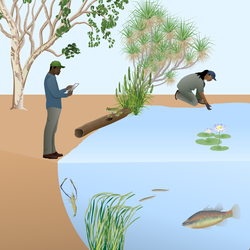
Freshwater places like gnammas (water holes), soaks and creeks are often important cultural sites, are water sources for humans, plants and animals, and provide habitat for aquatic plants and animals. Depending on what you want to know, you can monitor freshwater places to check on water quality, what plants are growing in or nearby, what animals are using or living there, or if there is disturbance (rubbish, vandalism or feral animals like camels or pigs).
Monitoring freshwater places involves visiting sites regularly and recording what you observe. This might include taking photos, measuring water levels, testing water quality, identifying plants and animals present, and noting any problems like erosion, pollution or damage.
Why is freshwater monitoring useful?
Track ecosystem health: Monitoring what plants and animals are using freshwater places can show you if the ecosystem is healthy and if there are any problems that need management.
Protect cultural sites: Regular monitoring means that important cultural sites are kept safe from damage. Monitoring can provide opportunities for people to learn traditional knowledge about water places while also gaining scientific skills.
What can it monitor?
Freshwater places monitor can monitor the freshwater places found on Country, including gnammas, claypans, soaks, creeks, rivers, lakes and artificial freshwater bodies like dams.
You can monitor one or more of the following at freshwater places:
- Dissolved oxygen – how much oxygen is in the water. This can tell you if the water is suitable for aquatic animals. Aquatic animals usually need high oxygen levels.
- Water temperature – how hot or cold the water is. This can tell you if the water is suitable for aquatic plants and animals. Warm water might be too hot for some species, and speeds up reactions that use up oxygen or creates toxic conditions like algal blooms.
- pH – how acidic or basic (alkaline) or the water is. This can tell you if there are nutrients or pollutants in the water, and if the water is suitable for aquatic plants and animals. A neutral pH reading (around 7) is usually a good sign.
- Conductivity – how much salt and minerals are dissolved in the water. High levels usually mean there are pollutants or too much salt.
- Turbidity – how clear or cloudy the water is. This can change how much sunlight can reach plants. High turbidity can indicate that there are erosion or pollution problems.
- Micro and macroinvertebrates living in the freshwater place
- Animals that use the freshwater place including birds, frogs, lizards and mammals
- Disturbance like rubbish and vandalism
What can you learn?
- Water quality – dissolved oxygen, water temperature, pH, conductivity and turbidity are common measurement used to learn about water quality.
- Biodiversity – what species of plant and/or animal are using the freshwater place
- Species richness – how many species of plant and/or animals are using the freshwater place
- Presence/absence – if and where frog species live on Country
- Occupancy - If enough surveys are done at different gnammas on Country, the presence/absence data can be used to estimate occupancy. This type of modelling helps to work how many places really have a species, even if they weren’t detected at every site. This can be used as an indicator of how large a population might be and if is getting smaller/bigger over time.
- Activity – how many times a species is detected during a survey. This can be used as an indicator of how large a population might be and if is getting smaller/bigger over time.
What can’t you learn?
Freshwater places monitoring can’t necessarily tell you about all of the different animal and plant species that are living in the area, particularly if they don’t live in, live near or use the freshwater.
Unless there has been a long-term monitoring program, you can’t know the exact historical condition of the freshwater place before human impacts.
Unless you take water samples and send them off for analysis, you can’t necessarily learn about what specific pollutants are found in the water.
Using freshwater monitoring the Right-way
REMEMBER! Any time you do work that might disturb or interfere with native animals and vegetation, particularly threatened species, you need to check with the state authorities to see if you need any approvals, such as scientific licences or animal ethics committee permits.
Surveys of different types of freshwater places will collect similar data but may need a different type of survey design. Below are some of the different types of freshwater places you can monitor, and some different types of freshwater monitoring you can do:
Wetland monitoring
Freshwater wetlands can be monitored with water quality measurements and vegetation assessments along transects.
You can learn more in the Environmental Monitoring Method: Wetland Monitoring (in development).
Gnamma monitoring
Gnammas can be monitored with water quality measurements, eDNA water sampling, micro and macro invertebrate sampling, and camera trapping.
You can learn more on the Things We Care About page and in the Environmental Monitoring Method: Gnamma Monitoring (in development).
eDNA water sampling
eDNA water samples can be collected from freshwater places to find out what animals, like fish, frogs and birds, are using the water on Country.
You can learn more on the How We Check On Things page and in the Environmental Monitoring Method: eDNA Water Sampling with EnviroDNA Kits (in development).
Primary sources
This landing page was developed using the following sources:
Primary sources
This landing page was developing using the following sources:
- DES (2018). Monitoring and Sampling Manual: Environmental Protection (Water) Policy. QLD Department of Environment and Science: Brisbane, QLD.
Tools and resources
Webpage version: GA-CM-GA-110326